Century House
Application and Determination
On June 9, 1992, the Snyder Estate Natural Cement District was officially entered in the Natural Register of Historic Places.
This extensive document carefully delineates borders and the Historic artifacts and buildings onsite.
This nomination is the product of a collaboration:
Preliminary draft nomination prepared for a National Historic Landmark proposal in June 1978 [the NHL process was not completed] ;
draft prepared by:
Ralph J. Christian and George R. Adams
American Association for State and Local History
Primary research undertaken and revised and expanded draftnomination prepared for the State and National Register nomination proposal in January 1992; draft prepared by:
Ralph J. Christian and George R. Adams
American Association for State and Local History
Primary research undertaken and revised and expanded draftnomination prepared for the State and National Register nomination proposal in January 1992; draft prepared by:
Gayle Grunwald and Dietrich Werner
Century House Historical Society
The Snyder Estate
State and National Register evaluation, technical review, revision, editing and typing of the State and National Register nomination proposal completed by staff of the New York State Historic Preservation Office in January-March 1992;
project staff:
Michael F. Lynch, P.E., R.A., Historic Sites Restoration Coordinator
Kathleen LaFrank, Historic Preservation Program Analyst
Photographs also document their state in 1992. It’s a large document – 100.2 Mb!
The Snyder Estate Natural Cement Historic District encompasses approximately 275 acres near Rosendale, in Ulster County, New York.
The nominated property includes the Snyder family estate properties (residences and dependencies) and a number of industrial resources (intact features, ruins and archeological sites) relating to four major cement manufacturing operations on this site:
- the Lawrence Cement Works and successor firms,
- the Beach Cement Works and successor firms,
- the Snyder Cement Works and
- the Century Cement Works.
Collectively, these historical, architectural, industrial and archeological features represent the largest and most significant concentration of historic resources associated with the Rosendale cement industry between 1825 and World War II. Although Rosendale cement district itself is a geological area of approximately thirty square miles that supported many other cement companies during the period of significance, the companies documented in this nomination were the largest and most important cement producers in the Rosendale district. This nominination could be expanded substantially to include a much more conprehensive history of Rosendale cement if sufficient research and survey is ever undertaken that supports the significance and integrity of a larger area.
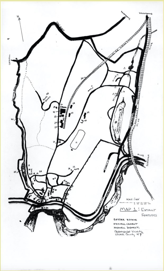
The boundary of the nominated district corresponds with those parcels owned by the four major cement producers mentioned above during the period of significance; it includes all major cement production features associated with these exmpanies and is defined by a combination of natural and historical features. Discontiguous parcels owned and/or used by these companies during the period of significance are of minor importance and have not been included. Possibly because cement was produced here until 1970, there has been remarkably little intrusive development with in the district. The district is generally bounded by Tan House Brook on the west, Rondout Creek on the south, Saw Dust Road on the north and Binnewater Road on the east; see tax map and item 10 for exact boundaries.
Because of its long and varied history, with features and owners overlapping, the district is more comprehensible when divided into sections based on the Snyder family’s occupation and the four major companies that used this site; however, some components may have been used by more than one company and in more than one period or by the same owner in different periods and/or with different companies. Resources have been grouped with their first or most significant users. Extant buildings and features are described first and an inventory of ruins and above-ground sites follows. Extant features are keyed by number in bold to the Extant Features Map [Map 1].